Exploring the Sarobetsu Plain by Campervan | Northern Hokkaido Wetlands & Views of Mt. Rishiri [2026 Edition]
A campervan guide to the Sarobetsu Plain in northern Hokkaido: daylily and cottongrass seasons, boardwalk walks, Mt.
Pick a campervan by what matters to you.
Rent at New Chitose Airport
See only the rental bases in Chitose, where the airport is.
Rent in winter (Dec–Mar)
Companies that rent through winter, listed apart from those that close.
Guide price
Moving Inn New Chitose Airport: HIACE van conversion from ¥22,000 per night. 20–30% off when booked 60–90 days ahead (official rate table, checked 15 Oct 2026).
New Chitose Airport map for campervan travellers →
Before you book: with an International Driving Permit if your country is in the Geneva Convention (for example the US, Australia, Singapore); Taiwan, Switzerland, Germany, France, Belgium and Monaco need your licence plus a Japanese translation (Tokyo Metropolitan Police). Questions in English: Moving Inn on WhatsApp. Every roadside station (michi-no-eki) must have free 24-hour toilets, and Hokkaido has 128 of them (MLIT).
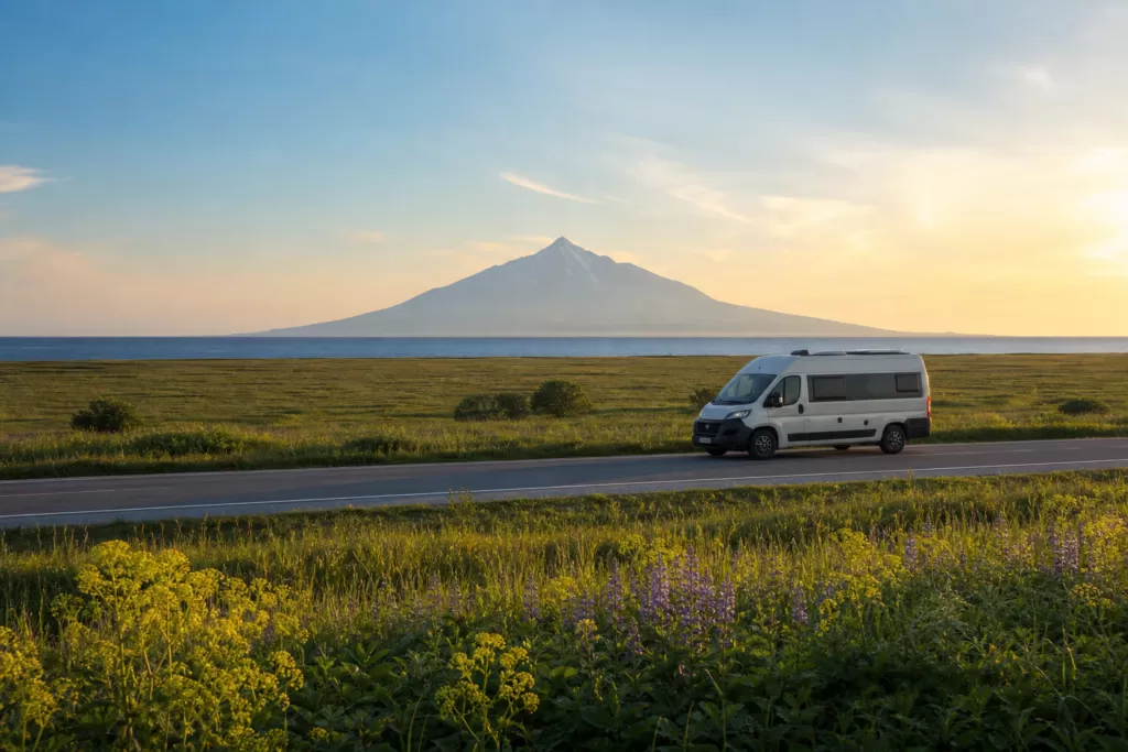
The Sarobetsu Plain is home to one of Japan’s largest raised bogs. Driving a campervan north along a dead-straight road in early summer — the wetland dyed orange-yellow by drifts of daylilies in June and July, cottongrass swaying its white tufts in the breeze — is one of the most memorable experiences any Hokkaido trip can offer. The Sea of Japan stretches out on your left, and beyond the utterly unobstructed plain, Mt. Rishiri (“Rishiri Fuji”) floats on the horizon. Travelers from across Japan and beyond head for Horonobe and Toyotomi in search of this very view.
The gateway to the Sarobetsu area is New Chitose Airport. Heading north on Route 40 via Asahikawa, it is about 350 km and 4–5 hours to Horonobe. It is a long drive, but Hokkaido’s national highways have few traffic lights and flow smoothly, so a campervan covers the distance more easily than you might expect. With the freedom to eat and rest inside the vehicle whenever you like, a campervan is inherently suited to this kind of long-distance touring. This article is a complete guide to a northern Hokkaido drive based around the Sarobetsu Plain.
The Nature of the Sarobetsu Plain and the Joy of the Drive
What Is a Raised Bog? — How Sarobetsu Was Formed
The Sarobetsu Plain spreads across roughly 6,700 hectares in northern Hokkaido, from the town of Horonobe to Toyotomi in Teshio District. It is a “raised bog,” built up over thousands of years from accumulated peat, and ranks among the largest in Japan. It is a Ramsar Convention wetland and is also protected as part of Rishiri-Rebun-Sarobetsu National Park.
The streams flowing through the wetland are reddish-brown — the color of tannins dissolved from the peat, not pollution. Peer down from the boardwalk and you can spot carnivorous plants like sundews and bladderworts among the green sphagnum moss. Part of the fun of walking Sarobetsu is discovering an ecosystem at your feet that you would never encounter in everyday life.
Flower Season — Daylilies and Cottongrass
The best time to visit Sarobetsu is late June to mid-July. During this period the wetland is blanketed in the vivid orange-yellow of Ezo daylilies (Ezo kisuge). The scale of the colonies is overwhelming — a boardwalk stretching through an endless field of flowers is a scene that, however many photos you have seen, hits differently in person.
From early to mid-June, cottongrass is at its peak. The white tufts trembling in the breeze are dreamlike, and the low slanting light of early morning makes for especially beautiful photographs. To enjoy both the daylilies and the cottongrass, aim for late June.
From August the vegetation shifts to summer species such as sedges and false hellebore, and September–October brings the season of autumn-tinted grasses. In spring (late May to early June) you can also see skunk cabbage. It is an area that rewards repeat visits.
The Long Straight Roads of Northern Hokkaido by Campervan
Route 40 and Prefectural Road 444 (the so-called “Sarobetsu Road” running along the western side of the plain) stretch north as if bisecting the wetland. Traffic is sparse, and driving with open moorland on both sides feels like a road at the end of the world. When Mt. Rishiri appears floating beyond the sea, travelers pull over one after another just to take it in.
Be aware, however, that this stretch is known for strong winds year-round. Crosswinds off the Sea of Japan are especially fierce between Horonobe and Wakkanai, and tall vehicles like campervans are particularly susceptible. If a gust hits, stay calm, keep a firm grip on the wheel and slow down. On days when the forecast says “strong northwesterly winds,” it is entirely reasonable to take the inland Route 40 first and save the Sarobetsu Road for when the wind dies down.
Compare Campervan Rentals in Hokkaido
Base yourself at New Chitose Airport and compare rates, vehicle types, and pickup locations all in one place.
Wetland Visitor Center and Boardwalk Guide
Sarobetsu Wetland Center (Toyotomi)
The gateway facility to the Sarobetsu Plain is the Sarobetsu Wetland Center in Toyotomi. The parking lot is spacious and campervans can park without any trouble. Inside, exhibits explain how the wetland formed and introduce its flora and fauna — useful for getting your bearings before heading out. Ask the staff about what is currently in bloom and they will tell you which sections of the boardwalk to focus on that day.
| Item | Details |
|---|---|
| Address | 8662 Kami-Sarobetsu, Toyotomi, Teshio District, Hokkaido |
| Hours | 9:00–17:00 (May–Oct), 10:00–16:00 (Nov–Apr) |
| Closed | Mondays from November to April (following day if a holiday) and December 29–January 3; open daily May–October |
| Admission | Free |
| Parking | Available (large vehicles OK), free |
A boardwalk extends from the center, with a course of about 2.5 km. Some sections get muddy, so rubber boots or trekking shoes are more comfortable than sneakers. Early morning (6:00–8:00) is quiet, and you can photograph the daylilies still holding morning dew. The center itself opens at 9:00, but the boardwalk can be walked in the early morning.
Viewing Areas Along the Toyotomi Bypass
Heading west from central Toyotomi on Prefectural Road 121, you will find viewing spaces scattered alongside the wetland. Park, pull out binoculars, and you may spot red-crowned cranes, tundra swans (spring and autumn) or white-tailed eagles. With a campervan you can duck back inside at any time, making it easy to grab warm layers or swap to a telephoto lens.
Wakasakanai Coast and the Dune Forest
West of the wetland lies the Wakasakanai dune forest, known as Japan’s northernmost sand dunes. The rare topography of dunes directly adjoining wetland means a single walking trail lets you observe both types of vegetation at once. It is well known among photographers as a spot where you can frame Mt. Rishiri head-on across the coastline.
Photography and Sunset Spots for Mt. Rishiri
Golden Hours and Compositions to Aim For
Mt. Rishiri (Rishiri-zan, 1,721 m) is an isolated volcanic peak rising straight from the sea, its cone beautiful from every angle. The classic composition — Mt. Rishiri across the Sea of Japan from the western edge of the Sarobetsu Plain — is one of the definitive shots of any Hokkaido photography trip.
The two best windows are sunset (18:00–20:00; the sun sets late in June and July) and early morning (4:30–6:00). At sunset, when side light rakes the mountain and the clouds turn pink to orange, the scene is overwhelming. In the early morning there is usually less haze and the mountain’s outline stands out crisply. If you want wetland cottongrass or daylilies in the foreground, crouch low and shoot at the height of the flowers for the best effect.
Main Photography Spots
| Spot | Features | Best Time |
|---|---|---|
| Wakasakanai Coast | Mt. Rishiri over dunes and sea; great compositional freedom | Sunset, early morning |
| Sarobetsu Wetland boardwalk area | Daylilies combined with Mt. Rishiri | Early morning to mid-morning |
| Farm roads near Toyotomi Onsen | Quintessential Hokkaido scene of hay rolls with Mt. Rishiri | Morning |
| Horonobe View Sky Observatory | Hilltop panorama of wetland and the Sea of Japan | Midday to sunset |
| Prefectural Road 444 (Sarobetsu Road) | Dead-straight road with Mt. Rishiri; shots including your vehicle are popular | Morning, sunset |
Clouds gather easily around Mt. Rishiri’s summit. Even on clear days, cloud often builds in the afternoon, so the standard tactic for a photo trip is to check the next morning’s forecast and move on “clear-sky mornings.” With a campervan, it is easy to overnight near a shooting spot and wait for dawn.
Night Photography and Stargazing Spots
The area around the Sarobetsu Plain has little light pollution, and the Milky Way is visible to the naked eye at night. The Wakasakanai coast and the boardwalk area near the Wetland Center are especially popular in July and August, when the Milky Way spans the southern sky. Many photographers aim for long-exposure compositions pairing the Milky Way with the silhouette of Mt. Rishiri. A flashlight and insect repellent are essential.
New Chitose Airport / Tokachi-Obihiro Airport
Rent the Cab-Over Camper “Cresson Journey”
Base yourself at New Chitose Airport and travel all across Hokkaido by campervan.
Roadside Stations, RV Parks and Overnight Parking in the Area
Overnight Parking Basics
Northern Hokkaido is well suited to sleeping in your vehicle. Roadside stations are dotted throughout, many with clean toilets. With fewer tourists, parking lots rarely fill up and you can park at ease. That said, during the daylily peak in July, photography traffic increases and the lots near the Wetland Center get busy on weekends.
Main Overnight and Stay Spots
| Facility | Type | Location | Approx. Cost | Features |
|---|---|---|---|---|
| Horonobe town center parking | Public parking | Horonobe | Free | No roadside station in Horonobe; the station-front lot is commonly used |
| Michi-no-Eki Teshio | Roadside station | Teshio | Free | Near the mouth of the Teshio River; large lot, 24-hour toilets |
| Michi-no-Eki Toyotomi Onsen | Roadside station | Toyotomi | Free (bathing extra) | Famous for Toyotomi Onsen and its distinctive petroleum-scented waters |
| Sarobetsu Wetland Center parking | Free parking | Toyotomi | Free | Overnight parking possible (observe good manners) |
| Wakkanai RV Park (Wakkanai) | RV park | Wakkanai | ¥1,500–2,500/night | Powered sites, good water and shower facilities |
Toyotomi Onsen is a rare petroleum-bearing hot spring, said to help with skin conditions, and it attracts many therapeutic bathers. The distinctive smell surprises some people, but the bath itself is a genuinely unique experience. Day bathing is available and works wonders on a travel-weary body. The hot spring facility is within walking distance of Michi-no-Eki Toyotomi Onsen.
Water, Waste Water and Fuel
Fuel stations are widely spaced in northern Hokkaido. Horonobe, Toyotomi and Wakkanai each have stations, but you may find none in the smaller settlements between them. Before leaving Wakkanai to head south, be sure to fill the tank in the city. Water can be refilled at roadside stations and similar facilities; RV parks also have waste-water disposal equipment.
Connecting Routes to Wakkanai, Rebun and Rishiri
From the Sarobetsu Plain to Wakkanai
From the Sarobetsu Wetland Center to central Wakkanai is about 60 km — just under an hour. You can take Route 40 north, or follow the Sea of Japan coast via Prefectural Road 106 and Route 232. In good weather the coastal route is the one to choose, with Mt. Rishiri keeping you company on your left. As noted above, however, this is a strong-crosswind section, so check the wind before committing.
In Wakkanai, a stop at Cape Soya (the northernmost point of Japan) is the classic move. It is about 30 km and 40 minutes from central Wakkanai. The cape has a monument and a row of eateries serving scallops and sea urchin. The parking lot at Cape Soya is large and handles campervans without difficulty.
Ferry Connections to Rishiri and Rebun Islands
Ferries run daily from the Wakkanai Ferry Terminal to Rishiri Island (Oshidomari Port), operated by Heartland Ferry. The crossing takes about 1 hour 40 minutes. Rebun Island (Kafuka Port) is roughly another 40 minutes beyond.
| Route | Duration | Approx. Fare (1 adult) | Vehicles |
|---|---|---|---|
| Wakkanai → Rishiri (Oshidomari) | Approx. 1 hr 40 min | From ¥2,890 (varies by season and class) | Yes (reservation required; vehicle fare extra) |
| Wakkanai → Rebun (Kafuka) | Approx. 2 hrs | From ¥3,040 | Yes (reservation required; vehicle fare extra) |
Taking a campervan on the ferry incurs a separate vehicle fare (based on length and weight; for a 4–5 m campervan, roughly ¥20,000–40,000 round trip as a guide). You can drive a campervan on the islands, but some roads are narrow, and vehicles over 5 m face restrictions on certain routes. Leaving the campervan parked in Wakkanai and crossing as a foot passenger is also a perfectly good option.
The Full Northern Hokkaido Route at a Glance
A standard north-south itinerary starting from New Chitose Airport looks like this.
| Day | Driving Leg | Approx. Distance | Overnight |
|---|---|---|---|
| Day 1 | New Chitose Airport → Asahikawa → Nayoro | Approx. 250 km | Nayoro city / roadside station |
| Day 2 | Nayoro → Horonobe → Sarobetsu wetland walk | Approx. 130 km | Horonobe / Toyotomi Onsen |
| Day 3 | Sarobetsu photography (early morning) → Wakkanai → Cape Soya | Approx. 90 km | Wakkanai RV Park |
| Day 4 | Rebun/Rishiri ferry excursion, or turn toward eastern Hokkaido | — | On the islands or toward Okhotsk |
Route 40 from Nayoro toward Horonobe and Wakkanai passes distinctive stops such as the village of Otoineppu, famous for Japan’s blackest soba noodles. With time to spare, add a night to enjoy the former Tempoku Line railway museum in Otoineppu or the dinosaur excavation sites of Nakagawa.
Preparation Checklist for a Northern Hokkaido Drive
Clothing and Gear
Summer in northern Hokkaido runs nearly 10°C cooler than mainland Japan, and even in July, nights can drop to around 15°C. Light clothing is fine for daytime, but carry one windproof, warm layer for mornings, evenings and windy conditions. On the wetland boardwalk, rubber boots or waterproof trekking shoes serve you well. Insect repellent spray, a long-sleeved layer and a hat are essential kit.
If photography is the goal, an ND (neutral density) filter helps with slow-shutter renderings of the wetland’s water surfaces and landscapes. A telephoto lens (200–400 mm) dramatically widens your options for bird watching and photography. A tripod is indispensable for sunset and night-sky shots.
Connectivity and Information
Mobile coverage is available in Horonobe, Toyotomi and Wakkanai, but you may lose signal deep in the wetland or on farm roads. Download offline maps (Google Maps offline areas, Maps.me and the like) before departure. Road conditions can be checked via the Hokkaido Regional Development Bureau’s road information service. Checking for wind, fog and construction closures both the night before and just before departure gives extra peace of mind.
Food and Water Resupply Points
Horonobe, Toyotomi and Wakkanai all have supermarkets and convenience stores; Teshio has one or two convenience stores as well. There is nowhere to shop within the wetland or along the farm roads, so the golden rule is to stock up on food and drink in Horonobe or Toyotomi before heading out. With a refrigerator and cooking equipment on board, buying groceries in bulk and self-catering keeps dining costs way down. Sourcing northern Hokkaido’s fresh ingredients — octopus, scallops, wild salmon — and cooking them in the van is one of the distinct pleasures of campervan travel.
Frequently Asked Questions (FAQ)
Q: When are the daylilies at their best on the Sarobetsu Plain?
The peak is typically late June to mid-July, shifting a week or two either way depending on the year. Bloom conditions can be checked on the Sarobetsu Wetland Center (Toyotomi) website or by phone. Cottongrass peaks from early to mid-June, so late June is the sweet spot for enjoying both.
Q: How should I handle strong winds in a campervan?
The Horonobe–Wakkanai stretch (especially coastal Prefectural Road 106 and Route 232) is prone to strong crosswinds. Check the JMA forecast and road information before setting out, and on days forecasting winds of 10 m/s or more, take the inland Route 40 instead. While driving, keep your speed down (80 km/h or less) and grip the wheel firmly on bridges and where windbreak forests give way to open ground. Tall cab-over campers are the most wind-sensitive type.
Q: Where can a campervan park overnight around the Sarobetsu Plain?
Michi-no-Eki Teshio (Teshio), Michi-no-Eki Toyotomi Onsen (Toyotomi) and Wakkanai RV Park (Wakkanai) are all convenient bases. The Sarobetsu Wetland Center parking lot has also been used, but confirm the facility’s rules in advance. Insects — especially blackflies and mosquitoes — are numerous in summer, so do not forget insect netting and repellent.
Q: Can I take a campervan on the ferry to Rishiri and Rebun?
Yes (Heartland Ferry, Wakkanai–Rishiri/Rebun routes). Vehicle loading requires a reservation, and slots fill early in the peak season (July–August). Booking in advance through the ferry’s official website is strongly recommended. Some island roads are narrow, and vehicles over 5 m long cannot pass certain sections. Leaving the vehicle in Wakkanai and crossing on foot is also worth considering.
Q: Can I rent a campervan at New Chitose Airport and drive to Sarobetsu?
Absolutely. From New Chitose Airport to the Sarobetsu Wetland Center is about 350 km and 4–5 hours (via Asahikawa and Nayoro). It is a long haul, but with the freedom to eat and rest inside the vehicle, fatigue is noticeably lower than in an ordinary rental car. Planning 2–3 nights with separate travel and sightseeing days makes for a relaxed trip. For comparing rental companies based at New Chitose Airport, our comparison page is a good place to start.
Book a Campervan in Hokkaido
Moving Inn New Chitose Airport supports English booking and offers airport transfers.
Pick a campervan by what matters to you.
Rent at New Chitose Airport
See only the rental bases in Chitose, where the airport is.

![Campgrounds Near Tokachi-Obihiro Airport: 8 Sites Within 30 km, Compared by Vehicle Access, Power and Price [2026]](https://hokkaido-campingcar.jp/wp-content/uploads/2026/10/photo-obihiro-airport-featured-pl232-768x512.jpg.webp)
![Campgrounds Near Hakodate Airport: 12 Sites Within 30 km, Compared by Vehicle Access, Power and Price [2026]](https://hokkaido-campingcar.jp/wp-content/uploads/2026/10/photo-hakodate-airport-featured-hl4722-768x484.jpg.webp)