Wakkanai & Soya Camper Van Drive Guide | Japan’s Northernmost Point, Cape Soya & Islands Complete Guide [2026]
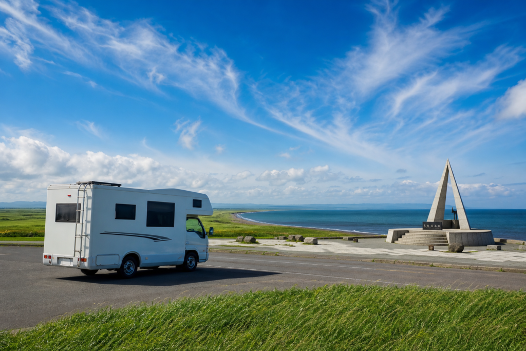
The Wakkanai and Soya area sits at the northernmost tip of Hokkaido — the northernmost point in all of Japan. Cape Soya, the White Road, Esanuka Line, and the Ororon Line pack in scenery found nowhere else in Hokkaido, making it a bucket-list route among camper van travelers. Add the islands of Rishiri and Rebun, reachable by ferry from Wakkanai Port, and even a full week won’t feel like enough.
This guide covers a 2-night, 3-day model itinerary departing from Asahikawa, along with practical information on key sights, RV parks, ferry arrangements, and a cost simulation.
Why Northern Hokkaido Is Perfect for a Camper Van Trip
There are three main reasons the Wakkanai and Soya region suits camper van travel.
- Thrilling straight roads: The Esanuka Line stretches 18 km in a perfectly straight line, while the Ororon Line hugs the coastline — scenery that looks even better at a camper van’s leisurely pace.
- Less crowded than other spots: Unlike Hakodate, Furano, or Otaru, this area doesn’t attract the same volume of tourists, making it easier to find parking and use overnight spots in peace.
- A sense of real adventure: Reaching the northernmost point of Japan delivers a feeling of accomplishment that genuinely elevates the whole trip.
From Asahikawa, access is via National Route 40 — about 260 km and 3 hours 10 minutes. Picking up a camper van at Asahikawa Airport and heading north is the most efficient approach. For rental options in Asahikawa, see our Asahikawa Camper Van Rental Comparison.
| Departure Point | Distance to Wakkanai City | Estimated Travel Time |
|---|---|---|
| Wakkanai Airport | Approx. 13 km | Approx. 20 min |
| Asahikawa City | Approx. 260 km | Approx. 3 hr 10 min (via Rt. 40 / Nayoro) |
| Asahikawa Airport | Approx. 270 km | Approx. 3 hr 20 min |
| New Chitose Airport | Approx. 395 km | Approx. 4 hr 50 min (Doo Expressway / via Asahikawa) |
Wakkanai Airport is small with limited direct flights, so Asahikawa Airport is the practical base. National Route 40 passes through Nayoro and Otoineppu, with roadside stations dotted along the way — a manageable long drive.
Classic Route: Wakkanai & Cape Soya — 2-Night, 3-Day Itinerary
A 2-night, 3-day loop departing from Asahikawa Airport. Distances and times are approximate.
Day 1: Asahikawa → Nayoro → Wakkanai (approx. 270 km)
- Pick up camper van at Asahikawa Airport (around 9:00 AM)
- Head north on Rt. 40. Stop at Nayoro (approx. 90 km / 1 hr 10 min) for lunch and fuel
- Otoineppu (approx. 150 km / 1 hr 50 min): small village along the Teshio River, famous for Otoineppu soba
- Michi-no-Eki Teshio (approx. 220 km): where the Sea of Japan first comes into view
- Arrive Wakkanai City (approx. 270 km / 3 hr 30 min): stay at Michi-no-Eki Wakkanai
Day 2: Wakkanai → Cape Soya → White Road → Esanuka Line (approx. 120 km)
- Noshappu Cape (approx. 4 km / 10 min from city center): morning view of Mt. Rishiri
- Drive east on Rt. 238 to Cape Soya (approx. 30 km / 40 min from city)
- White Road on the Soya Hills (approx. 3 km from Cape Soya): 5 km unpaved — recommended for kei campers and van conversions
- Head south toward Hamatonbetsu; join Esanuka Line (Sarufutsu Village), approx. 60 km / 1 hr from Cape Soya
- Stay at Soya Fureai Park Auto Campsite or a van-camping spot near Sarufutsu Village
Day 3: Head South → Sarobetsu Wetlands → Ororon Line (approx. 200 km)
- Sarobetsu Wetland Center (Horonobe Town, approx. 50 km south of Wakkanai): boardwalk stroll through the marshlands
- Lunch at Michi-no-Eki Sarobetsu
- Drive south on Ororon Line with multiple stops at viewpoints for Mt. Rishiri
- At Haboro (approx. 180 km from Wakkanai), turn east on Rt. 239 toward Asahikawa
- Return camper van to Asahikawa Airport (next morning)
If you plan to visit Rebun or Rishiri Island, add at least one night and plan for 3 nights or more.
Complete Guide to Key Sights in Northern Hokkaido
Cape Soya — Japan’s Northernmost Point
Located at 45°31’22” N latitude, Cape Soya is the northernmost point in Japan. The Monument to the Northernmost Land and Cape Soya Lighthouse draw a steady stream of visitors. Parking is free with large-vehicle spaces available (confirmed May 2026). Several souvenir shops and restaurants are nearby. Even on busy summer weekends, camper van parking is generally not an issue.
Cape Soya is about 30 km / 40 minutes from Wakkanai city via Rt. 238. Restrooms are available at the monument site (free).
White Road on the Soya Hills
South of Cape Soya, a roughly 5 km road paved with crushed scallop shells winds across the hills. The panoramic view of the Soya Sea and Mt. Rishiri from the hilltop is one of Hokkaido’s iconic photo spots. The surface is unpaved and gravel-like, so large cab-over campers should proceed with caution. Van conversions and kei campers handle it without trouble.
Esanuka Line (Sarufutsu Village)
An approximately 18 km perfectly straight road through Sarufutsu Village. Low grasslands stretch to the horizon on both sides — a sight unlike anything else. Lightly trafficked, it lets you feel completely immersed in the landscape. The entrance is between Sarufutsu and Hamaonikishi on Rt. 238, about 60 km south of Wakkanai. Fully paved and accessible even for large cab-over campers.
Ororon Line (Rt. 232 / Prefectural Road 106)
A coastal drive running south from Wakkanai toward Rumoi, with the Sea of Japan on the left and Mt. Rishiri ahead. The stretch around Toyotomi and Embetsu offers particularly stunning views on clear days. The road is wide and comfortable for camper vans. For the southern section from Rumoi, see our Mashike–Rumoi Ororon Line North Guide.
Sarobetsu Wetlands & Sarobetsu Wetland Center
A vast wetland in Horonobe Town blooming with seasonal wildflowers — Ezo Hemerocallis (July) and cottonsedge (June), among others. Free admission, with boardwalk paths through the marsh. Red-crowned cranes are sometimes spotted at dawn and dusk. About 50 km / 40 minutes south of Wakkanai, adjacent to Michi-no-Eki Sarobetsu.
Noshappu Cape
At the western tip of Wakkanai city, this cape offers beautiful views of Mt. Rishiri — especially at sunset when the mountain and the sun align. Only about 4 km / 10 minutes from the city center. The Noshappu Cold Current Aquarium is right next door (admission: ¥500 adults / ¥250 children, confirmed May 2026).
Ferry Trip to Rebun Island & Rishiri Island
Heartland Ferry operates from Wakkanai Port to Rishiri and Rebun Islands. Both offer distinctive natural landscapes unlike mainland Hokkaido, and many travelers include them as a northern trip highlight. For general camper van island ferry tips, see our Practical Guide to Ferry Travel and Island Camping.
| Route | Travel Time | Adult One-Way Fare (approx.) | Vehicle Loading (passenger car class) |
|---|---|---|---|
| Wakkanai → Rishiri (Oshidomari) | Approx. 1 hr 40 min | ¥2,860 (2nd class) | From ¥19,480 (varies by vehicle length and season) |
| Wakkanai → Rebun (Kafuka) | Approx. 1 hr 55 min | ¥2,860 (2nd class) | From ¥19,480 |
Fares vary by season and vehicle size. For details and reservations, see the Heartland Ferry official website (confirmed May 2026).
Tips for Loading Your Camper Van on the Ferry
- Book vehicle space early: Summer (July–August) weekend slots fill up fast. Reserve at least 1–2 months in advance.
- Vehicle class and length: Ferry vehicle fares are based on 4 m, 5 m, and 6 m length classes. Large cab-overs often fall in the 6 m class. Confirm your rental vehicle’s length before booking.
- Island road conditions: Some island roads are narrow — van conversions and kei campers are more suitable. If sightseeing is the goal, consider leaving your camper van in Wakkanai and taking the ferry as a foot passenger.
- Island camping: Both islands have campgrounds (Rishiri: approx. ¥500–¥1,000/night). Confirm parking availability for your camper van in advance.
Highlights of Rishiri Island
The two big draws are climbing Mt. Rishiri (Rishiri-Fuji) and Rishiri kombu kelp. The summit hike from Hime-numa trailhead takes about 7–9 hours round trip. Non-climbers can enjoy a scenic drive along the island’s circular road (approx. 28 km) past Hime-numa, Numaura Observation Deck, and Otatomari Pond.
Highlights of Rebun Island
Known as the “Floating Island of Flowers,” Rebun features alpine plants blooming from sea level — including Rebun Atsumori-sou (peak: early June–July). The Momoidwa Observation Trail (approx. 3 hours) and Sukai Cape are top attractions. The island is a long, narrow 29 km from north to south, with no circular road.
RV Parks & Overnight Spots in Northern Hokkaido
| Facility | Location | Approx. Cost | Notes |
|---|---|---|---|
| Michi-no-Eki Wakkanai | Wakkanai City | Free (overnight parking) | Adjacent to Wakkanai Station and ferry terminal. 24-hr restrooms. Arrive early in summer due to crowds. |
| Soya Fureai Park Auto Campsite | Wakkanai (near Cape Soya) | ¥2,000–¥3,500/night | Electric hookup sites. Approx. 20 min drive to Cape Soya. Paid showers available. |
| Wakkanai Forest Park Campground | Wakkanai City | Approx. ¥500/night | Municipal campground close to the city. Basic facilities — good for budget travelers. |
| RV Park Wassamu Fureai-no-Mori | Wassamu Town (midway between Asahikawa and Wakkanai) | ¥1,000–¥2,000/night | Electric hookup and 24-hr restrooms. Conveniently located as a midpoint stop. |
| Michi-no-Eki Sarobetsu | Horonobe Town | Free (overnight parking) | Next to Sarobetsu Wetland Center. Handy rest/overnight stop along the Ororon Line heading south. |
| Michi-no-Eki Teshio (Ororon Line) | Teshio Town | Free (overnight parking) | Coastal rest stop just before Wakkanai. 24-hr restrooms available. |
RV parks in northern Hokkaido fill up during peak season (June–August). For July–August visits, start making reservations at least a week in advance by phone or online.
Cost Estimate (Rental + Fuel + Accommodation)
Based on a 2-night, 3-day trip departing from Asahikawa Airport. Actual costs vary by vehicle type, season, and total distance.
| Cost Item | Kei Camper (2 people) | Van Conversion (4 people) | Cab-Over (4–6 people) |
|---|---|---|---|
| Rental fee (2 nights / 3 days) | Approx. ¥26,000–¥76,000 | Approx. ¥40,000–¥116,000 | Approx. ¥52,000–¥188,000 |
| Fuel (est. 550 km total) | Approx. ¥4,500 (15 km/L) | Approx. ¥6,100 (11 km/L) | Approx. ¥8,200 (8 km/L) |
| Accommodation (2 nights, RV park) | Approx. ¥2,000–¥5,000 | Approx. ¥2,000–¥5,000 | Approx. ¥3,000–¥7,000 |
| Food & misc. (2 nights / 3 days) | Approx. ¥6,000–¥12,000 | Approx. ¥12,000–¥20,000 | Approx. ¥12,000–¥20,000 |
| Total estimate | Approx. ¥38,500–¥98,000 | Approx. ¥60,000–¥147,000 | Approx. ¥75,000–¥223,000 |
Add the vehicle ferry fare (from ¥19,480/vehicle) and passenger tickets if visiting Rebun or Rishiri. A 3-night, 4-day plan including a ferry crossing typically adds ¥10,000–¥20,000 to the total.
Fuel estimates are based on approximately 640 km total (540 km Asahikawa–Wakkanai round trip + 100 km local driving). Gas prices in northern Hokkaido are typically ¥170–¥185/L (confirmed May 2026).
Compare Camper Van Rentals in Northern Hokkaido / Wakkanai
Browse and compare prices, vehicle types, and pickup locations in Asahikawa and northern Hokkaido.
Compare Rental Companies & Rates →Best Season & Travel Tips for Northern Hokkaido
Best Times to Visit
| Month | Weather / Temperature | Highlights | Crowds |
|---|---|---|---|
| June | 15–22°C, mostly sunny | Rebun Island alpine flowers, Sarobetsu cottonsedge | Low–Moderate |
| July | 18–24°C, mostly sunny | Sarobetsu Ezo Hemerocallis, White Road | High |
| August | 20–24°C, partly sunny | Peak season for all sights | Very High |
| September | 13–20°C, cooler | Early foliage, crowds begin to thin | Low–Moderate |
July–August is the most comfortable period, but parking near Cape Soya and popular overnight spots can get crowded. From September onward, the area quiets down significantly — early September is ideal for travelers who prefer a more relaxed pace.
Things to Watch Out For
- Bring warm layers: Even in July–August, nighttime temperatures drop to around 15°C. Pack a fleece or light down jacket.
- Fog and strong winds: The area is prone to morning fog. Drive cautiously on the White Road or Esanuka Line in foggy conditions. Keep speed below 80 km/h on coastal roads. For bad-weather strategies, see our Hokkaido Camper Van Bad Weather Guide.
- Fill up before heading north: Gas stations are sparse around Sarufutsu Village and the Esanuka Line area. Tank up in Wakkanai city before heading toward Cape Soya.
- White Road after rain: Mud can form after heavy rain. Avoid entering immediately after rainfall and check road conditions first.
- Book the ferry early: Heartland Ferry vehicle space for July–August opens two months in advance. Book as soon as your dates are set.
FAQ
Can I park a camper van at Cape Soya?
Yes. The parking lot at Cape Soya is free and includes large-vehicle spaces (confirmed May 2026). It gets busy on summer weekends, but large-vehicle spots don’t fill up as quickly — you should be fine arriving later in the day.
Can a camper van drive on the Esanuka Line?
Yes. The Esanuka Line is a paved public road and accessible to large cab-over campers. The road is wide enough for easy passing. Just be mindful of cyclists and motorcycles when overtaking.
Can I bring a camper van to Rishiri or Rebun Island?
Yes. Heartland Ferry has vehicle loading capacity. However, fares are high (from ¥19,480/vehicle) and summer slots fill up fast. Some island roads are narrow, so van conversions and kei campers are better suited. For large cab-overs, leaving the vehicle in Wakkanai and taking the ferry as a foot passenger is a practical alternative.
Is Wakkanai cold even in summer?
It’s cooler than most other parts of Hokkaido. Daytime temperatures in July–August reach around 20–24°C, but nights drop to about 15°C. Prepare a light down jacket or blanket when sleeping in your camper van.
Can I reach Wakkanai from Asahikawa in one day?
Yes. The standard route via Rt. 40 is about 260 km / 3 hours 10 minutes. With rest stops at Nayoro, Otoineppu, and Teshio, you can arrive in Wakkanai by evening. Budget extra time if you plan to sightsee along the way.
Can I combine a northern Hokkaido trip with Furano and Biei?
Absolutely. Using Asahikawa as a hub, you can cover both the northern route toward Wakkanai and the Furano/Biei area. Five to six nights is enough to do both. For the Furano and Biei route, see our Furano–Biei Camper Van Drive Guide.
What should I watch out for when driving a camper van in northern Hokkaido?
Three main things. First, crosswinds: the Ororon Line and Esanuka Line are exposed to strong winds — keep your cruising speed at or below 80 km/h. Second, fuel management: gas stations are sparse between Sarufutsu Village and Cape Soya, so fill up in Wakkanai city first. Third, ground clearance: the White Road is unpaved, and high-roof or low-clearance vehicles risk bottoming out. Check your rental camper’s minimum ground clearance before attempting it.