Teshio and Horonobe Campervan Guide: Sarobetsu Wetlands and the Northern End of the Sea of Japan Orollon Line [2026 Edition]
A campervan guide to Teshio and Horonobe near the north end of the Orollon Line: the Otonrui Wind Farm's 28 turbines, the free Yumechisoukan research center, and the Teshio River's shijimi clam industry.
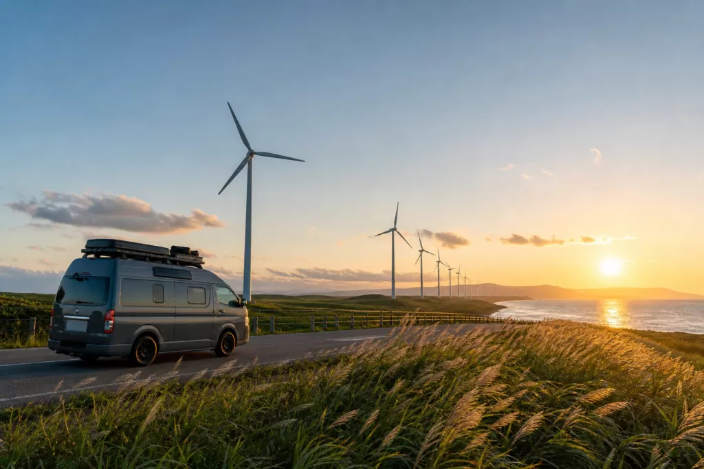
Along the Sea of Japan coast, 28 wind turbines stand in a single line stretching 3.1 km north to south — the Otonrui Wind Farm. Each turbine generates 750 kW, for a combined output of 21,000 kW, and the farm has been in full operation since February 2003. It sits along Hokkaido Route 106 (the Wakkanai-Teshio Line, better known as the Orollon Line) in the Hamasato district of Horonobe (Town of Horonobe official site, checked 2026-08-25). Few people realize that right next to the area known for the Sarobetsu wetlands and Mt. Rishiri photo spots, there’s a place where you can experience this kind of large-scale engineering up close.
Teshio and Horonobe are two towns positioned near the final stretch of the Orollon Line, not far from Wakkanai. Teshio sits where the Teshio River meets the Sea of Japan, while Horonobe hosts a “science and energy” side of the region, with its wind farm and geological disposal research. Both are small towns with populations in the 2,000–3,000 range (Teshio Town official tourism site / Horonobe Town official population statistics, checked 2026-08-25), but a campervan stop here shows a different side of the area than the wetland and Mt. Rishiri views everyone talks about.
This article takes a different angle from our Sarobetsu Wetlands Campervan Guide, which centers on the Sarobetsu wetlands and Mt. Rishiri photography. Here we focus on the towns of Teshio and Horonobe themselves, and the industries and facilities you’ll find there. We leave the wetland walks and the Rishiri/Rebun ferry details to that article, and instead cover Teshio- and Horonobe-specific stops — the Otonrui Wind Farm, the Horonobe Underground Research Center’s “Yumechisoukan” exhibition hall, and the shijimi clam industry at the mouth of the Teshio River — along with practical visiting information.
New Chitose Airport / Tokachi-Obihiro Airport
Rent the “Cresson Journey” cab-conversion camper
Base yourself at New Chitose Airport and travel all across Hokkaido by campervan.
See details at Moving Inn →Where Teshio and Horonobe sit along the Orollon Line
The “Sea of Japan Orollon Line” is a nickname for the string of roads — National Route 231, Route 232, Prefectural Route 106, and others — that run north along the Sea of Japan coast from Ishikari and Rumoi up to Wakkanai. Route 232 is a general national route running from Wakkanai City to Rumoi City, and the stretch from Teshio Town (Teshio District) to Rumoi City forms part of the Orollon Line (Wikipedia, “National Route 232,” checked 2026-08-25). We’ve covered the Mashike/Rumoi area in our Mashike and Rumoi Campervan Guide, where the stretch from Haboro through Horonobe to Wakkanai only gets a brief mention as a pass-through route.
Teshio and Horonobe sit right at the tail end of that “pass-through” stretch. From Teshio it’s about a one-hour drive to central Wakkanai, and Horonobe is even closer (Teshio Town official tourism site, checked 2026-08-25). While many travelers use the area mainly as a last rest stop on the way to Wakkanai and Cape Soya, the mouth of the Teshio River and Horonobe’s wind farm and research facilities have sights that are genuinely worth more than a drive-by.
Strictly speaking, Japan’s northernmost city, Wakkanai, is the true “northern end” of the Orollon Line, but Teshio and Horonobe come right before it — the stretch where the flat coastal road along the Sea of Japan gives way to the Sarobetsu wetlands. If you’re extending your trip to Wakkanai and Cape Soya, see our Wakkanai and Cape Soya Campervan Driving Guide.
Otonrui Wind Farm: 28 turbines lined up over 3.1 km along the Sea of Japan
One of Horonobe’s signature sights is the Otonrui Wind Farm. According to Horonobe Town’s official site, 28 turbines stand in a row over 3.1 km, north to south, in the Hamasato district along Prefectural Route Wakkanai-Teshio (the Orollon Line). Each turbine produces 750 kW, for a total output of 21,000 kW; the farm has been fully operational since February 2003, the turbines stand 99 m tall, and the site is said to supply about 50 million kWh a year to Hokkaido Electric Power’s Horonobe substation (Town of Horonobe official site, checked 2026-08-25).
The sight of turbines lined up in a straight row against the Sea of Japan and the horizon has a completely different scale from the Sarobetsu wetlands. There are spots along the road where you can pull over and take it in, though the official site doesn’t specify how many dedicated parking spaces exist. If you pull onto the shoulder, watch for passing traffic and be careful opening doors in strong wind. As also noted in our Sarobetsu article, this stretch along the Sea of Japan tends to see strong winds year-round, and a tall campervan is more affected by crosswinds.
Horonobe Underground Research Center’s “Yumechisoukan”: free admission to a geological disposal research site
Worth pairing with the Otonrui Wind Farm is the Horonobe Underground Research Center in the Kitashin district of Horonobe. Operated by the Japan Atomic Energy Agency (JAEA), the center conducts research and development on geological disposal technology for high-level radioactive waste, and visitors can tour underground facilities such as research shafts, above-ground facilities, and “Yumechisoukan,” an exhibition hall introducing the research (JAEA official site, checked 2026-08-25).
Yumechisoukan is located at 432-2 Kitashin, Horonobe, Teshio District, Hokkaido. It’s open 9:00–16:00 with free admission. It’s closed every Monday and over the New Year holidays (December 29–January 3); if a public holiday falls on a closing day, it’s closed the following Wednesday instead (JAEA official site, checked 2026-08-25). There’s also a separate “underground facility tour” that lets you see the underground facilities, but the schedule and application process change according to the site’s announcements, so check JAEA’s official site for the latest information before visiting. The contact number is 01632-5-2772 (same source, checked 2026-08-25).
It’s in the same Kitashin district of Horonobe as the Sarobetsu Wetland Center, so it’s an easy add-on to a wetland walk. For the wetland center’s hours and boardwalk details, see our Sarobetsu Wetlands Campervan Guide.
The 45th Parallel North Monument: an easy-to-miss marker along the Sea of Japan
In western Horonobe, along the Orollon Line near Wakisakanai Coast, stands the “45th Parallel North Monument.” It marks the exact point where Prefectural Route 106 crosses the 45th parallel north, with an “N” marked on the Sea of Japan (west) side and a sign on the road (east) side indicating the crossing point. Parking is limited to just two or three spaces, and the monument itself is easy to miss since it doesn’t stand out.
Beyond marking the latitude exactly halfway between the equator and the North Pole, there’s nothing else here — it’s the kind of stop where you take a photo and move on. It’s conveniently located if you’re already planning a Mt. Rishiri photo stop at Wakisakanai Coast.
Teshio Town: where the Teshio River meets the Sea of Japan
Teshio is a town of about 3,000 people on the Sea of Japan coast (Teshio Town Tourism Association official site, checked 2026-08-25). The Teshio River, which runs through the town, is Hokkaido’s second-longest river, and its mouth is said to be home to natural-monument white-tailed and Steller’s sea eagles as well as the sheatfish (Japanese huchen), Japan’s largest freshwater fish (same source, checked 2026-08-25). The town’s main industries are dairy farming and fishing, with large-grain shijimi clams as a local specialty (same source, checked 2026-08-25).
Sitting between the mouth of the Teshio River and Lake Kagami is Kagaminuma Beach Park. According to Teshio Town’s official site, volunteers are working toward planting a million rugosa roses on the hill to the west, and the park is open from May 1 through late October (9:00–21:00) (Town of Teshio official site, checked 2026-08-25). The park includes a campground with 13 bungalows, 8 auto-camping sites, and free sites, with rates available on the official fee schedule (same source, checked 2026-08-25). We couldn’t find explicit confirmation on the official site as to whether campervan overnight parking is allowed, so check directly with the facility before visiting.
Michi-no-Eki Teshio: shijimi ramen, fuel, and shopping
Michi-no-Eki Teshio serves as Teshio Town’s hub. It’s located at 7227-2 Shinkaidori 4-chome, Teshio, along National Route 232, about an hour from Wakkanai and about two hours from Rumoi (Town of Teshio official site, checked 2026-08-25). The restaurant is open 11:00–17:00 April through December and 11:00–15:00 January through March; the shop is open 10:00–17:00 April through December and 10:00–15:00 January through March. Restrooms and vending machines are available 24 hours (same source, checked 2026-08-25).
The restaurant serves shijimi clam soup and shijimi ramen, and the shop sells processed goods such as fresh shijimi, frozen shijimi, sweet-and-spicy miso shijimi, and shijimi croquettes (Town of Teshio official site, checked 2026-08-25). Beyond shijimi, dairy specialties like Teshio ChuChu pudding and Bekochichi Factory’s handmade cheese are also available (same source, checked 2026-08-25). Pack some frozen shijimi in your campervan’s fridge and you’ll have material for cooking in the vehicle the next day.
The Michi-no-Eki’s official site makes no mention of a fuel stand, so you’ll need to fill up at gas stations in Teshio’s town center. Gas stations are spaced far apart along the Horonobe–Teshio–Wakkanai stretch, so it’s worth topping off the tank in town before continuing toward Wakkanai. For the broader picture of overnight parking and water/drainage across the Dohoku region, see our Sarobetsu Wetlands Campervan Guide.
Compare Hokkaido campervan rentals
Base yourself at New Chitose Airport and compare rates, vehicle types, and pickup locations all in one place.
Compare rental companies and rates →Driving National Route 232 between Teshio and Horonobe
To get from Teshio to Horonobe, you can either take National Route 232 slightly inland, or follow Prefectural Route 106 (the Orollon Line) along the Sea of Japan coast. Taking the coastal route lets you pass Wakisakanai Coast, the 45th Parallel North Monument, and the Otonrui Wind Farm on your way toward Horonobe and Wakkanai. This stretch has light traffic and is easy to drive, but it’s also known for strong winds year-round — on a day when the forecast calls for “strong northwest winds,” it’s a reasonable call to take the inland National Routes 40/232 instead.
Specific advice on handling crosswinds (recommended speeds, steering technique) is covered in the FAQ of our Sarobetsu Wetlands Campervan Guide — worth reviewing before you drive the Horonobe–Wakkanai stretch.
Where to park overnight or the night before
In Teshio Town, the main overnight option is Michi-no-Eki Teshio, which has restrooms available 24 hours. That said, a Michi-no-Eki is meant for napping and short rests, not extended stays or cooking. Kagaminuma Beach Park’s campground has auto-camping and free sites, but whether campervans are permitted, and the rates, need to be confirmed with the facility directly (as of 2026-08-25, the official site doesn’t explicitly state whether overnight parking is allowed).
On the Horonobe side, options include the Sarobetsu Wetland Center parking area, Michi-no-Eki Toyotomi Onsen, and Wakkanai RV Park. Details on these (approximate costs, facilities) are listed in the table in our Sarobetsu Wetlands Campervan Guide. To search for RV parks across Hokkaido more broadly, see Hokkaido RV Park Directory (47 JRVA-certified sites).
Pairing this trip with Sarobetsu, Wakkanai, and Rishiri/Rebun
Most travelers don’t stop at just Teshio and Horonobe, but combine them with the surrounding area. For an itinerary that also includes the Sarobetsu wetland walks, Mt. Rishiri photo spots, and the ferry connections to Rishiri and Rebun, see our Sarobetsu Wetlands Campervan Guide; for the highlights of Cape Soya and central Wakkanai, see our Wakkanai and Cape Soya Campervan Driving Guide.
If you’re building a route from the opposite direction — coming up from Nayoro and Bifuka to the south toward Teshio and Horonobe — see our Dohoku, Bifuka, and Nayoro Campervan Guide. If you want to work in nighttime stargazing photography, our Hokkaido Campervan Stargazing Photography Guide is a useful reference — the Teshio and Horonobe area has little light pollution and is also known as a spot for photographing the wind turbine silhouettes against a starry sky.
Sample route: heading north from Rumoi and staying one night in Teshio/Horonobe
If you’re traveling the Orollon Line from south to north, the standard route is to enjoy seafood and sunset views in the Mashike/Rumoi area, then head to Teshio and Horonobe via Haboro and Enbetsu. For driving notes and Michi-no-Eki information on the Mashike/Rumoi side, see our Mashike and Rumoi Campervan Guide. Once you reach Teshio, a good one-night plan is to eat shijimi ramen at Michi-no-Eki Teshio, take a break at Kagaminuma Beach Park, then visit the Otonrui Wind Farm and Yumechisoukan in Horonobe before heading north toward Wakkanai.
With more time, you could stay one night in Teshio/Horonobe and dedicate the following full day to the Sarobetsu boardwalk and Mt. Rishiri photography. If you’re timing your visit to the wetland flowering season (June–July), positioning your Teshio/Horonobe overnight as the night before your wetland walk makes it easier to hit the boardwalk early in the morning.
Things to confirm before you go
- Have you checked JAEA’s official site for the underground facility tour’s schedule and application process? (The Horonobe Underground Research Center is closed Mondays and over the New Year holidays.)
- Is a strong wind advisory in the forecast for the area around the Otonrui Wind Farm? If so, have you considered the inland route instead?
- Have you confirmed with the facility whether overnight parking is allowed, and the rates, for Kagaminuma Beach Park’s campground and Michi-no-Eki Teshio?
- Have you topped off your fuel in Teshio or Horonobe town, given how far apart gas stations are along the Horonobe–Wakkanai stretch?
- The figures in this article were confirmed as of 2026-08-25 — have you double-checked the official sites just before your trip?
Frequently asked questions
How is this article different from the Sarobetsu Wetlands Campervan Guide?
The Sarobetsu article centers on the wetland’s flowers, the boardwalk, Mt. Rishiri photo spots, and the ferry connection to Rishiri/Rebun. This article focuses instead on the towns of Teshio and Horonobe themselves, covering stops the Sarobetsu article doesn’t — the Otonrui Wind Farm, the Horonobe Underground Research Center’s “Yumechisoukan,” the shijimi clam industry at the mouth of the Teshio River, and Kagaminuma Beach Park. For the wetland walk and Mt. Rishiri details, see our Sarobetsu Wetlands Campervan Guide.
Can you visit the Otonrui Wind Farm at any time?
The turbines are an outdoor power facility that you view from along the road. According to Horonobe Town’s official site, 28 turbines stand in a row over 3.1 km, north to south, and the farm has been fully operational since February 2003 (checked 2026-08-25). We haven’t found any mention of a dedicated visitor facility or how many parking spaces are available, so if you pull onto the shoulder, watch for other vehicles and be careful in strong wind.
What is “Yumechisoukan” at the Horonobe Underground Research Center, and how much does it cost?
It’s an exhibition hall run by the Japan Atomic Energy Agency (JAEA), introducing its research on geological disposal technology for high-level radioactive waste. Admission is free, it’s open 9:00–16:00, and it’s closed every Monday and over the New Year holidays (JAEA official site, checked 2026-08-25). A separate tour lets you see the underground facilities — check the official site for the current schedule.
Where can I get shijimi ramen in Teshio?
At Michi-no-Eki Teshio, along National Route 232. The restaurant is open 11:00–17:00 April through December and 11:00–15:00 January through March (Town of Teshio official site, checked 2026-08-25). The shop also sells take-home items like frozen shijimi and sweet-and-spicy miso shijimi.
Are there places to park overnight around Teshio and Horonobe?
Michi-no-Eki Teshio has restrooms and vending machines available 24 hours. Kagaminuma Beach Park’s campground is another option, but confirm directly with the facility whether campervans are permitted. On the Horonobe side, the Sarobetsu Wetland Center parking area, Michi-no-Eki Toyotomi Onsen, and Wakkanai RV Park are convenient — details are in our Sarobetsu Wetlands Campervan Guide.
How far is it from Teshio/Horonobe to Wakkanai and Cape Soya?
According to Teshio Town’s official site, it’s about a one-hour drive from Teshio to central Wakkanai (checked 2026-08-25). From Horonobe, it’s even closer. For the highlights of Wakkanai and Cape Soya, see our Wakkanai and Cape Soya Campervan Driving Guide.
If I’m driving the Orollon Line from south to north, can I combine this with Rumoi and Mashike?
Yes. The standard Orollon Line route is to enjoy the seafood and sunset spots of the Mashike/Rumoi area, then head north through Haboro and Enbetsu to Teshio and Horonobe. For details on the Mashike/Rumoi side, see our Mashike and Rumoi Campervan Guide.
Book a Campervan in Hokkaido
Moving Inn New Chitose Airport supports English booking and offers airport transfers.