How Long Does a Hokkaido Loop Take by Campervan? 13 Days, 12 Nights and About 2,090 km at 200 km a Day [2026]
How long does a Hokkaido campervan loop take? Capped at 200 km a day, the shortest is 13 days, 12 nights and about 2,090 km. Route table and 15-day option.
Pick a campervan by what matters to you.
Rent at New Chitose Airport
See only the rental bases in Chitose, where the airport is.
Rent in winter (Dec–Mar)
Companies that rent through winter, listed apart from those that close.
Guide price
Moving Inn New Chitose Airport: HIACE van conversion from ¥22,000 per night. 20–30% off when booked 60–90 days ahead (official rate table, checked 15 Oct 2026).
New Chitose Airport map for campervan travellers →
Before you book: with an International Driving Permit if your country is in the Geneva Convention (for example the US, Australia, Singapore); Taiwan, Switzerland, Germany, France, Belgium and Monaco need your licence plus a Japanese translation (Tokyo Metropolitan Police). Questions in English: Moving Inn on WhatsApp. Every roadside station (michi-no-eki) must have free 24-hour toilets, and Hokkaido has 128 of them (MLIT).
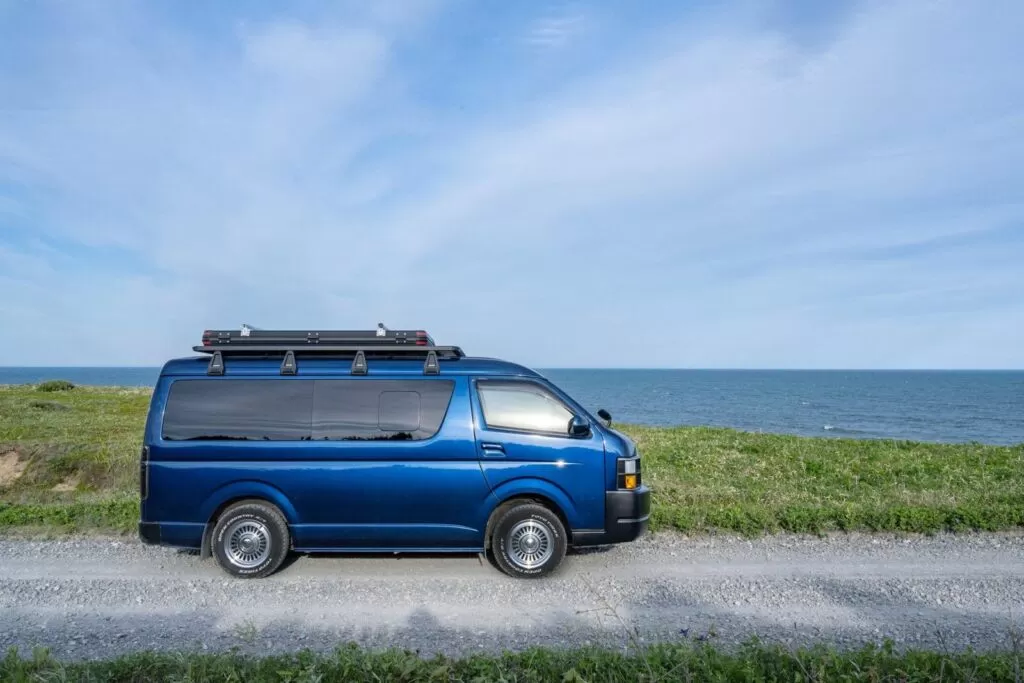
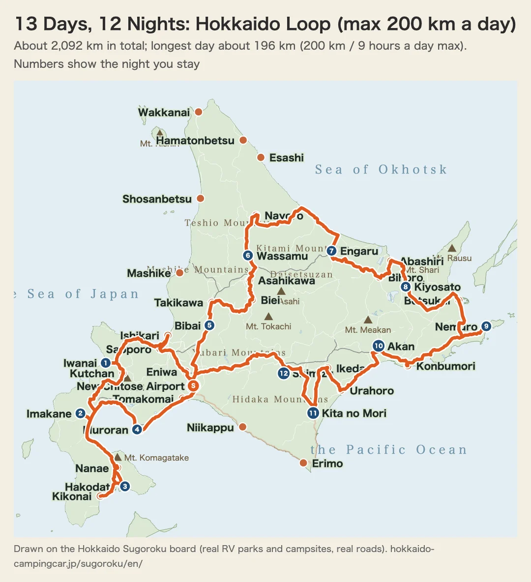
In short, if you loop around Hokkaido by campervan and cap each day’s driving at 200 km and 9 hours, the shortest trip is 13 days and 12 nights; allow 15 days and 14 nights if you want some breathing room. Leaving New Chitose Airport and linking RV parks where a campervan can stay overnight by real roads, the full loop comes to about 2,090 km. Even 200 km is a fairly long day once you add sightseeing and breaks, so we recommend not stretching it any further.
If you are not doing the full loop, narrow down the regions you cover to match the number of days. The table below shows plans that start and end at New Chitose Airport, built around places where you can stay overnight and the limit of 200 km and 9 hours a day (calculated from the leg data of our Hokkaido Sugoroku, October 5, 2026).
| Trip length | Area covered | Total distance | Longest day |
|---|---|---|---|
| 6 days, 5 nights | Central Hokkaido + Tokachi and Erimo (stay at Kita no Mori) | about 499 km | about 146 km |
| Central Hokkaido + Southern Hokkaido (Setana, Hakodate, Lake Toya) | about 861 km | about 187 km | |
| Central Hokkaido + Northern Hokkaido (round trip to Asahikawa and Nayoro) | about 631 km | about 126 km | |
| 8 days, 7 nights | Central Hokkaido + a Southern Hokkaido loop (Matsumae, Hakodate, Muroran) | about 767 km | about 161 km |
| Central Hokkaido + Tokachi and Kushiro (as far as Akan, returning via Erimo) | about 851 km | about 146 km | |
| Central Hokkaido + Wakkanai (July–August only) | about 1,125 km | about 183 km | |
| 10 days, 9 nights | Central Hokkaido + Southern Hokkaido + Erimo and Tokachi | about 1,318 km | about 174 km |
| Central Hokkaido + Eastern Hokkaido (as far as Abashiri and Kiyosato, returning via Engaru and Nayoro) | about 1,086 km | about 188 km | |
| 13 days, 12 nights | Full Hokkaido loop (shortest; night 11 at Kita no Mori) | about 2,092 km | about 196 km |
| 15 days, 14 nights | Full Hokkaido loop + Shakotan (Cape Kamui) and Lake Mashu | about 2,268 km | about 196 km |
| Full Hokkaido loop (with shorter days) | about 2,092 km | about 182 km |
You stay only at RV parks and campsites where a campervan can park overnight (the 40 locations on the Hokkaido Sugoroku board). Figures are calculated for summer roads (May–October); winter is a separate matter. For the Wakkanai plan, the campsites where you can stay are open only in July and August.
Search for “Hokkaido loop campervan” and many sites repeat the same figures: “about 3,000 km in total, 10 to 14 days.” Trace those figures to their source, though, and you find only secondhand information with no underlying data, so there is no way to tell which legs were added up or how. This article does not use those figures as they are. Starting from New Chitose Airport, we checked 12 legs that actually link Central, Southern, Northern, and Eastern Hokkaido one by one on map services and added them up. Simply connecting the major cities came to about 1,750 km in total, with a combined pure driving time of about 29 hours 20 minutes (breaks and sightseeing time not included). That is considerably shorter than the “3,000 km” often seen online, but the difference comes from the premise: ours is a practical loop connecting major cities and bases, not the total distance of faithfully tracing the coastline out to every cape.
The primary source we had planned to use was the “distance and time search” function of “Kita no Michi Navi,” run by the Hokkaido Regional Development Bureau of the Ministry of Land, Infrastructure, Transport and Tourism and the Civil Engineering Research Institute for Cold Region (https://northern-road.ceri.go.jp/navi/). However, when we tried to access it several times at the time of writing (2026-08-25), the search tool’s page kept returning 403 errors or empty responses, and connections to related domains failed, so we could not obtain figures in a form usable in this article. Instead, we cross-checked each leg against several map and road information sites, including NAVITIME, Tabirai, and kosoku.jp (an expressway toll search site), and use only the figures we could confirm, each marked in the form “(site name, checked 2026-08-25).” Kita no Michi Navi is still the proper primary source, so for the latest check before you leave, give priority to Kita no Michi Navi and announcements from road administrators.
About 1,750 km Just Connecting the Major Cities (Without Considering Where to Stay)
Starting from New Chitose Airport, we checked the distance and travel time of each leg on a practical loop: Central Hokkaido (Otaru, Niseko, Lake Toya) → Southern Hokkaido (Hakodate) → north via Central Hokkaido → Northern Hokkaido (Asahikawa, Nayoro) → Eastern Hokkaido (Abashiri, Shiretoko, Kushiro, Obihiro) → back to New Chitose Airport. The travel times in the table are estimates for expressway use and do not include breaks or sightseeing.
| Leg | Distance (approx.) | Travel time (approx.) | Notes and sources |
|---|---|---|---|
| New Chitose Airport → Otaru | about 78 km | about 55 min | Via the Do-o Expressway and Sassho Expressway (kosoku.jp, Tabirai, checked 2026-08-25) |
| Otaru → Niseko | about 60 km | about 1 hr 15 min | Local roads (NAVITIME search result, checked 2026-08-25) |
| Niseko → Lake Toya | about 42 km | about 45 min | Local roads (NAVITIME search result, checked 2026-08-25) |
| Lake Toya → Hakodate | about 180 km | about 2 hr 40 min | Via the Do-o Expressway (aggregated from Tabirai-type sites, checked 2026-08-25) |
| Hakodate → New Chitose Airport area | about 280 km | about 3 hr 45 min | Via the Do-o Expressway. To head for Northern and Eastern Hokkaido, you have to come back to this area first (Tabirai, checked 2026-08-25) |
| New Chitose Airport area → Asahikawa | about 175 km | about 2 hr | Via the Do-o Expressway (aggregated from several sites, checked 2026-08-25) |
| Asahikawa → Nayoro | about 74 km | about 1 hr (estimate) | Local roads. The distance matched across several sources, but the stated travel times varied, so this is an estimate calculated from driving speed |
| Nayoro → Abashiri | about 314 km | about 6 hr | Local roads (aggregated from several sites, checked 2026-08-25). Long for a single day of driving |
| Abashiri → Shiretoko (Utoro) | about 105 km | about 3 hr 15 min | National Routes 244 and 334 (aggregated from Shiretoko-area sightseeing sites, checked 2026-08-25) |
| Shiretoko (Utoro) → Kushiro | about 165 km | about 3 hr 30 min | Via Shari (aggregated from several sites, checked 2026-08-25) |
| Kushiro → Obihiro | about 115 km | about 2 hr | Via the Do-to Expressway (kosoku.jp, checked 2026-08-25) |
| Obihiro → New Chitose Airport | about 161 km | about 2 hr 15 min | Via the Do-to Expressway (kosoku.jp, NAVITIME, checked 2026-08-25) |
The 12 legs total about 1,750 km, with a pure driving time of about 29 hours 20 minutes. But some legs here, such as Hakodate → New Chitose Airport area (about 280 km) and Nayoro → Abashiri (about 314 km), exceed 200 km in a single day. And we have not yet decided where to stay. If you link places where a campervan can stay overnight and split the trip into days of 200 km or less, the full loop becomes about 2,090 km and a minimum of 13 days and 12 nights (see the table at the top and the model route below).
Clockwise or Counterclockwise: How to Choose Your Direction
The 12 legs above are physically the same roads traveled in reverse, so the total distance and pure driving time are the same whether you go clockwise (Central → Southern → Northern → Eastern Hokkaido) or counterclockwise (Eastern → Northern → Southern → Central Hokkaido). What decides the direction is where you pick up the campervan and which ferry port you arrive at. If you pick up at New Chitose Airport, there is no big difference either way. If you arrive by ferry at Tomakomai Port or Otaru Port, clockwise lets you head straight into Central Hokkaido from the port with the least wasted travel. Conversely, if you arrive by ferry at Kushiro Port, it is better to start in Eastern Hokkaido and go around through Northern Hokkaido, Southern Hokkaido, and Central Hokkaido, so you never have to double back from the port. If you are considering entering Hokkaido by ferry, check how to plan a route from each port in the Hokkaido Ferry and Campervan Travel Guide, then decide which direction to use this article’s route.
Model Route: 13 Days and 12 Nights from New Chitose (Up to 200 km a Day)
The table below links places where you can stay overnight, clockwise, and splits the trip so that no day exceeds 200 km or 9 hours. The leg distances are the same as in Hokkaido Sugoroku, calculated on real roads.
| Day | Route | Driving distance | Where you stay |
|---|---|---|---|
| Day 1 | New Chitose Airport → Eniwa → Sapporo → Ishikari → Iwanai | about 182 km | Iwanai · RV Park Hotel Inou |
| Day 2 | Iwanai → Kutchan → Imakane | about 130 km | Imakane · RV Park Pirika |
| Day 3 | Imakane → Kikonai → Hakodate | about 172 km | Hakodate · RV Park Hakodate Ryokuen-dori |
| Day 4 | Hakodate → Nanae → Muroran | about 189 km | Muroran · RV Park Muroran ZEKKEI BASE CAMP |
| Day 5 | Muroran → Tomakomai → Bibai | about 171 km | Bibai · Bibai RV Park |
| Day 6 | Bibai → Takikawa → Biei → Asahikawa → Wassamu | about 164 km | Wassamu · RV Park Wassamu Fureai no Mori |
| Day 7 | Wassamu → Nayoro → Engaru | about 196 km | Engaru · RV Park Engaru Town Hotel Sunshine |
| Day 8 | Engaru → Bihoro → Abashiri → Kiyosato | about 149 km | Kiyosato · RV Park Shiretoko Kiyosato Uenewusaru Midori |
| Day 9 | Kiyosato → Betsukai → Nemuro | about 164 km | Nemuro · RV Park Midori |
| Day 10 | Nemuro → Kushiro | about 164 km | Kushiro · RV Park Akan Tancho no Sato |
| Day 11 | Kushiro → Urahoro → Ikeda → Taiki | about 175 km | Taiki · RV Park Moving Inn Tokachi Kita no Mori |
| Day 12 | Taiki → Shimizu | about 85 km | Shimizu · RV Park Tokachi Wakka no Mori |
| Day 13 | Shimizu → New Chitose Airport (return) | about 152 km | (Return) |
The total is about 2,090 km, an average of about 160 km a day. The longest days are Day 7 (Wassamu → Engaru, about 196 km, about 3 hours of driving) and Day 4 (Hakodate → Muroran, about 189 km), so plan these two as travel days with shorter sightseeing. The trip cannot be shorter than 13 days and 12 nights because some stretches between places where you can stay are long (Onuma → Muroran about 161 km, Nayoro → Engaru about 146 km, and so on), and the only option is to split the day there.
The night 11 stop, Kita no Mori, is the RV Park Moving Inn Tokachi Kita no Mori in Taiki. At the end of the day you come down from Akan to Tokachi, and you can spend one night in the forest.
New Chitose Airport / Tokachi-Obihiro Airport
Rent the Cabcon “Cresson Journey”
Base yourself at New Chitose Airport and compare rates, vehicle types, and pickup locations all in one place.
See Details at Moving Inn →If You Extend to 15 Days and 14 Nights (Side Trips, or Shorter Days)
The 13-day, 12-night trip is mostly travel, so time in each area is short. If you add two days to make 15 days and 14 nights, there are two ways to use them.
The first is side trips. Stay two nights in Iwanai and make a day trip to Cape Kamui on the Shakotan Peninsula and back (about 101 km), and stay two nights in Kiyosato and make a day trip to the Lake Mashu First Observation Deck and back (about 76 km). The total comes to about 2,270 km, and the longest day is about 196 km, the same as the 13-day, 12-night trip.
The second is to add no side trips and split the days into shorter ones. If you change your overnight stops to Kikonai, Onuma, Biei, Nayoro, Ikeda, and so on, the longest day drops to about 182 km (this version does not stay at Kita no Mori). If you are not used to driving or are traveling with children, this one is less tiring. Both sets of distances are real-road figures, and winter road closures are not taken into account.
How Far Is a Comfortable Day’s Drive?
On this site, we limit a day’s driving by campervan to 200 km and 9 hours. We could not find any official, unified standard for how many kilometers is safe, but even 200 km makes for a fairly long day once you add sightseeing, meals, and breaks. A campervan has a larger body than a passenger car, and driving fatigue builds up more easily. On a day when you would go over 200 km because there is nowhere to stay, split the trip across two days. The tables and the model route in this article are all built to this limit. On longer days, it helps to leave early in the morning, take frequent breaks at Michi-no-Eki, and cut sightseeing short to spend the time on driving.
How Much Does It Cost?
Rental rates and conditions at each base tend to change by company and season, so this article does not include a specific price table and instead points to comparison articles and each company’s official page. For a price comparison for rental periods of 13 days and 12 nights and of 15 days and 14 nights, see How to Keep Hokkaido Campervan Rental Costs Down and the Complete Guide to Hokkaido Campervan Model Courses.
For expressway tolls, there are amounts we could confirm on official sites for some sections. The Otofuke-Obihiro IC to Chitose-Higashi IC section (equivalent to the Kushiro → Obihiro → New Chitose area leg) is ¥3,730 for a standard vehicle, the Otofuke-Obihiro IC to Kushiro section is ¥1,130 for a standard vehicle, and the Chitose IC to Otaru IC section is ¥2,110 for a standard vehicle (all from kosoku.jp, checked 2026-08-25). We could not confirm tolls for the other sections in this article, so before you leave, check the latest amounts on the NEXCO East Japan toll search or in the Hokkaido Expressway Toll Guide. Fuel costs depend on the vehicle’s fuel economy and the gasoline price at the time, so the surest approach is to estimate from the rental vehicle’s stated fuel economy, using the total distance of about 2,090 km (more if you add side trips) as a guide.
Area Side Trips and Base Stays Are Covered in Dedicated Articles
This article is a backbone route for linking all of Hokkaido in a single trip, and it does not cover every sightseeing spot or candidate place to stay within each area. Individual routes of 3 to 7 nights for each area are covered in their own dedicated articles.
| Area | Legs covered in this article | Detailed route article |
|---|---|---|
| Central Hokkaido | New Chitose Airport, Otaru, Niseko, Lake Toya | Central Hokkaido Campervan Model Route (3–5 Nights) |
| Southern Hokkaido | Hakodate | Southern Hokkaido Campervan Route Guide (6 Days, 5 Nights) |
| Northern Hokkaido | Asahikawa, Nayoro | Northern Hokkaido, Bifuka and Nayoro Campervan Travel Guide |
| Eastern Hokkaido | Abashiri, Shiretoko, Kushiro, Obihiro | Eastern Hokkaido Cross-Region Campervan Model Route (5–7 Nights) |
If you want to take your time in one specific area, it is easiest to plan by taking only that area’s legs from this loop backbone and fitting in the candidate places to stay and sightseeing spots from the individual articles above. Niseko on its own is covered in the Niseko Campervan Travel Roundup, the Lake Shikotsu direction in the Lake Shikotsu Campervan Guide, Hakodate and Southern Hokkaido in the Hakodate and Southern Hokkaido Campervan Travel Guide, Onuma Park in the Onuma Park Campervan Guide, Shiretoko in the Shiretoko Campervan Guide, Kushiro in the Kushiro Campervan Rental Guide, and the Sarobetsu Plain in Northern Hokkaido in the Sarobetsu Plain Campervan Guide.
If You Arrive in Hokkaido by Ferry, How Should You Plan the Loop?
If you bring your campervan from Honshu by ferry, you can use this article’s route just by changing the starting point to match your arrival port. If you arrive at Tomakomai Port or Otaru Port, start clockwise from Central Hokkaido; if you arrive at Kushiro Port, start counterclockwise from Eastern Hokkaido, which gives the shortest travel from the port. For details on ferry routes and operators, see the Hokkaido Ferry and Campervan Travel Guide. If you plan to start your trip by renting a campervan at New Chitose Airport, see the New Chitose Airport Campervan Rental Guide.
How Often Should You Plan Fuel, Water, and Overnight Stops?

In Eastern and Northern Hokkaido, gas stations are farther apart than on Honshu, and on some stretches the next one can be more than 50 km away. Whether you take the 13-day, 12-night or the 15-day, 14-night plan, make a point of stopping at the next gas station once your tank drops below half. Among places and Michi-no-Eki where you can stay overnight, some are officially stated as allowed and some are not, so this article does not state definitively whether any individual place is allowed and instead points to articles with confirmed lists. For general overnight parking rules across Hokkaido, see the Complete Guide to Overnight Parking in Hokkaido; for a list of Michi-no-Eki where you can stay overnight, see 20 Recommended Michi-no-Eki for Overnight Parking; and if you plan to use RV parks, check the latest confirmation status in the Hokkaido RV Park Guide before building them into your itinerary.
Can You Loop Hokkaido in Winter?
Winter closure sections on national and prefectural roads change with each year’s snowfall, and the legs covered in this article include roads through mountainous areas. This article does not state definitively which sections close from which month; instead, before you leave, check the latest situation for your season in the road information of the Hokkaido Regional Development Bureau and each subprefectural bureau, or in the mountain pass information on “Kita no Michi Navi.” For equipment and precautions when driving a campervan in winter, see the Winter Hokkaido Campervan Travel Guide, and for preparing studless tires, see When to Switch to Studless Tires for a Hokkaido Campervan. The number of days in this article is calculated for summer roads (May–October). If you plan to travel in winter, whether on the 13-day, 12-night or the 15-day, 14-night schedule, read these two articles first and plan on reworking the route to avoid closed sections.
If you are planning for winter with about 10 days, our 10-day winter itinerary offers a January course and a February course from New Chitose Airport instead of a full loop, with a place to stay each night and every day within 200 km.
Campervan Types Suited to a Loop Route
On a loop route of 13 days and 12 nights or more, where you move and stay overnight almost every day with your luggage loaded, both comfort inside the vehicle and ease of driving matter. A detailed comparison of what each vehicle type is and is not suited for is in the Complete Guide to Hokkaido Campervan Model Courses, so check it together with the itineraries by number of days before narrowing down your vehicle.
Frequently Asked Questions (FAQ)
Q. How many km and how many days does a Hokkaido loop take in the end?
Linking RV parks where a campervan can stay overnight by real roads comes to about 2,090 km, and with a limit of 200 km and 9 hours a day, the shortest trip is 13 days and 12 nights (calculated from the leg data of our Hokkaido Sugoroku). Simply connecting the major cities without considering where to stay comes to about 1,750 km, but some days would then be 280 km or 314 km.
Q. Which do you recommend, clockwise or counterclockwise?
The total distance and travel time are the same in either direction. If you arrive by ferry at Tomakomai Port or Otaru Port, or start from New Chitose Airport, go clockwise (Central → Southern → Northern → Eastern Hokkaido); if you arrive at Kushiro Port, go counterclockwise (start from Eastern Hokkaido). That way no travel from the port or airport is wasted.
Q. Can you loop Hokkaido in 10 days and 9 nights?
With a limit of 200 km and 9 hours a day, you cannot do the full loop in 10 days and 9 nights. For 10 days and 9 nights, Central Hokkaido + Eastern Hokkaido (as far as Abashiri and Kiyosato) or Central Hokkaido + Southern Hokkaido + Tokachi and Erimo is a good guide. For the full loop, plan on at least 13 days and 12 nights.
Q. What can you add if you have 14 days or more?
With 15 days and 14 nights, you can add a day-trip round trip from Iwanai to Cape Kamui on Shakotan (about 101 km) and a day-trip round trip from Kiyosato to the Lake Mashu First Observation Deck (about 76 km). Each means staying two nights in the same place. If you add no side trips and split the days into shorter ones, the longest day drops to about 182 km.
Q. How many km a day is a good guide?
This site sets the limit at 200 km and 9 hours a day. Even 200 km is a little long once you add sightseeing and breaks. On a day when you would go over because there is nowhere to stay, split the trip across two days.
Q. How much should I budget for a Hokkaido loop?
Rental rates change by company and season, so this article does not list specific prices. For expressway tolls, only for the sections we could confirm: Otofuke-Obihiro IC to Chitose-Higashi IC is ¥3,730 for a standard vehicle, Otofuke-Obihiro IC to Kushiro is ¥1,130 for a standard vehicle, and Chitose IC to Otaru IC is ¥2,110 for a standard vehicle (kosoku.jp, checked 2026-08-25). For fuel costs, estimate from the rental vehicle’s stated fuel economy, using the total distance of about 2,090 km as a guide.
Q. How many nights should I allow for each of Central, Southern, Northern, and Eastern Hokkaido?
For a 13-day, 12-night loop, the split is 3 nights in Central Hokkaido (Iwanai, Muroran, Bibai), 2 in Southern Hokkaido (Imakane, Hakodate), 1 in Northern Hokkaido (Wassamu), 4 in Eastern Hokkaido (Engaru, Kiyosato, Nemuro, Kushiro), and 2 in Tokachi (Kita no Mori, Shimizu). If you want to spend more time in each area, see the individual articles built around 3–5 nights in Central Hokkaido, 6 days and 5 nights in Southern Hokkaido, and 5–7 nights in Eastern Hokkaido (the Central, Southern, Eastern, and Northern Hokkaido articles linked in the main text), and extend the days only for the areas that interest you.
Q. If I come to Hokkaido by ferry, where should I start the loop?
Heading straight into the nearest area from the port where you arrive wastes the least travel. From Tomakomai Port or Otaru Port, start clockwise from Central Hokkaido; from Kushiro Port, start counterclockwise from Eastern Hokkaido. For detailed route information, see the Hokkaido Ferry and Campervan Travel Guide.
Q. How often should I refuel and refill water?
Some stretches in Eastern and Northern Hokkaido have widely spaced gas stations, so the rule is to stop at the next gas station once your tank drops below half. For places to stay overnight and Michi-no-Eki, refer to the officially confirmed list articles, and do not decide on your own whether staying is allowed at places that are not officially stated.
Q. Can you loop Hokkaido in winter?
Winter closure sections on national and prefectural roads change with each year’s snowfall, so this article does not state them definitively. Before you leave, check the latest closure status for your season in the road information of the Hokkaido Regional Development Bureau and each subprefectural bureau or in the mountain pass information on “Kita no Michi Navi,” and then plan.
Q. What kind of campervan suits a loop route?
Because the itinerary involves moving and staying overnight every day for 13 days and 12 nights or more, both comfort inside the vehicle and ease of driving are the keys to choosing. Compare the characteristics of each vehicle type in the Complete Guide to Hokkaido Campervan Model Courses, and choose together with the itineraries by number of days.
Pre-Departure Checklist
Here is a summary of the above as items to check before you leave.
| Item to check | Why check it |
|---|---|
| Ferry arrival port / airport pickup location | Decides whether you plan clockwise or counterclockwise |
| Departure time for the longest days (Day 7, Wassamu → Engaru, about 196 km; Day 4, Hakodate → Muroran, about 189 km) | Driving time is longer than on other days, so an early start is needed |
| Side trips if you extend to 15 days and 14 nights | Cape Kamui is about 101 km round trip from Iwanai, and the Lake Mashu First Observation Deck is about 76 km round trip from Kiyosato. Make these two-night stays |
| Expressway toll sections not yet confirmed | This article identified only some sections. Check the latest amounts on the NEXCO East Japan toll search |
| Winter closure sections for the season you travel | They change every year, so check Kita no Michi Navi and road administrator announcements for your season |
| Fuel level and distance to the next gas station | In Eastern and Northern Hokkaido, some stretches have widely spaced gas stations |
New Chitose Airport / Tokachi-Obihiro Airport
Rent the Cabcon “Cresson Journey”
Base yourself at New Chitose Airport and compare rates, vehicle types, and pickup locations all in one place.
See Details at Moving Inn →Book a Campervan in Hokkaido
Moving Inn New Chitose Airport supports English booking and offers airport transfers.
Pick a campervan by what matters to you.
Rent at New Chitose Airport
See only the rental bases in Chitose, where the airport is.

![When and Where Can You See Harbor Seals at Cape Erimo? Kaze no Yakata Official Information, Viewing Season, and Windy-Day Notes [2026-27]](https://hokkaido-campingcar.jp/wp-content/uploads/2026/10/erimo-cape-lighthouse-768x511.jpg.webp)
![Where and Under What Conditions Can You See Diamond Dust in Hokkaido? How Cold a Morning It Takes, and Where It Appears [2026-27]](https://hokkaido-campingcar.jp/wp-content/uploads/2026/10/hokkaido-diamond-dust-nayoro-768x512.jpg.webp)
![Can You Drive to Hokkaido Jingu for Hatsumode? Parking, Crowds, and Where to Park and Walk [2027]](https://hokkaido-campingcar.jp/wp-content/uploads/2026/10/hokkaido-jingu-winter-torii-768x504.jpg.webp)
![Hokkaido Roads Over New Year [2026-27] | Expressway Sections Prone to Blizzard Closures, Forecast Congestion Days, No Holiday Discount, and New Chitose Airport Parking](https://hokkaido-campingcar.jp/wp-content/uploads/2026/10/hokkaido-winter-rural-road-edge-markers-768x432.jpg.webp)
![Where to See Sea Smoke (Kearashi) in Hokkaido: Rumoi’s Ogon-misaki and the Morning Conditions [2026-27]](https://hokkaido-campingcar.jp/wp-content/uploads/2026/10/rumoi-kearashi-sea-smoke-768x511.jpg.webp)
![Geminid Meteor Shower 2026 in Hokkaido: Peak Around 23:00 on December 14, Sapporo Moonset 20:40, and Staying Warm in a Winter Campervan [2026]](https://hokkaido-campingcar.jp/wp-content/uploads/2026/10/geminids-2026-hokkaido-768x575.jpg.webp)